Top Land Surveyor in Mumbai, Navi Mumbai, Maharashtra <link rel="stylesheet" href="assets/css/external.css">

At our company, we have licensed surveyors who are certified experts in providing a wide range of engineering surveying solutions. We also boast a team of qualified engineers, GIS experts, and retired staff from the Revenue Department of Maharashtra, bringing a wealth of experience to our services. With proficiency in utilizing the latest technologies such as DGPS, ETS, and drones, we deliver precise and efficient surveying services for land surveying, topographic mapping, and alignment surveys. Whether for government, semi-government, or private infrastructure projects, our team is equipped to meet your surveying needs with professionalism and expertise. Our comprehensive suite of services includes topographic land surveys, contour surveys, and CAD deliverables, which can be offered separately or in combination to best suit your project requirements.

Land & Contour Survey

Land & Contour Survey

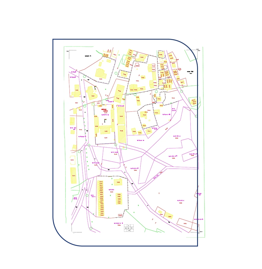
Our services encompass topographic land surveys and contour surveys, both of which can be offered separately. Our topographic surveys provide a comprehensive overview of your land's features, while contour surveys precisely outline elevation changes. Additionally, we provide all survey results in CAD format for easy integration into your design and planning processes, whether you choose one or both of these services. This flexibility ensures that we meet your specific project needs.

Client Projects

Key Features


75,000 Ha. Land Surveyed


200+ Satisfied Clients


Cadastral & Revenue Survey

Our surveying services include cadastral surveys, which are essential for understanding land ownership and property boundaries. These services provide a comprehensive understanding of land boundaries, easements, and encumbrances. With our meticulous approach and advanced surveying techniques, we ensure that our clients have a crystal-clear view of their land's legal and physical dimensions including the collection of revenue data from state revenue departments such as 7/12 abstract (saat bara), 8A Abstract, Village Maps, Gut Book, Gut Scheme, Fer Far, City Survey Sheets, Property card, and all other relevant revenue documents for cadastral and revenue work. Additionally, our revenue survey services address the complexities of revenue assessment. Our team, including experts with experience in state revenue departments, understands the details involved.

Client Projects

Key Features


Extensive Revenue Records Database


25+ Years of Land Revenue Expertise

Cadastral & Revenue Survey


Gis-Gps Survey

Gis-Gps Survey

Our GIS GPS survey service sets the standard for precision and accuracy in geographic data collection. Equipped with the latest DGPS (Differential Global Positioning System) technology and the latest software applications, we provide a cutting-edge solution for your mapping and surveying needs. Our modern equipment ensures that every data point is captured with unparalleled precision, allowing for highly detailed and reliable geospatial information. Whether you're in need of land surveys, asset management, environmental mapping, or any other geospatial project, our GIS GPS survey service, powered by advanced technology and compatible software, guarantees a level of quality that exceeds expectations.

Client Projects

Key Features


Cutting-Edge Surveying Equipment & Software Highly Skilled & Trained


Highly Skilled & Trained Professionals


Route & Final Location Survey

Our route and final location survey service is essential for the efficient development of roads, railways, high-tension power lines, gas lines, water supply networks, sewerage systems, and mobile tower installations. We provide expert planning and precise surveys to identify optimal routes and locations for these vital infrastructure projects, ensuring their success and sustainability.

Client Projects

Key Features


Decades of Industry Knowledge


Effective Communication with Project-Affected Persons (PAPs)

Route & Final Location
Survey


Drone Survey

Drone Survey

Our drone survey service stands out with the expertise of DGCA-approved licensed qualified drone pilots, ensuring a top-tier experience. Leveraging cutting-edge drone technology, our fleet is registered with the Directorate General of Civil Aviation (DGCA), guaranteeing compliance with rigorous safety and regulatory standards. This commitment to excellence extends to our comprehensive range of surveying and mapping solutions, covering everything from land surveying and infrastructure inspections to environmental monitoring. By combining state-of-the-art drones, DGCA-approved licensing, and an unwavering dedication to safety and precision, we've become the go-to choice for unparalleled aerial insights in high-quality survey services.

Client Projects

Key Features


Trained Drone Pilots


Over 1000 Hectares Surveyed by Our Team


SRA Survey

As an empanelled agency within the (Slum Rehabilitation Authority) SRA Mumbai, we offer comprehensive SRA surveys tailored to your specific needs. Our services encompass door-to-door biometric surveys and topographic surveys, ensuring a detailed understanding of the project area in alignment with both client and SRA requirements. What sets us apart is our commitment to precision, with all survey data submissions in the WGS 84 grid, meticulously GIS-mapped and coordinates referenced to the SRA's base stations. This dedication to accuracy and adherence to SRA standards make us the trusted choice for SRA surveys in the Mumbai Metropolitan Region, facilitating effective slum rehabilitation and urban development initiatives.

Client Projects

Key Features


Government Empanelment


Pioneering in Mumbai

SRA Survey


Licensed Surveyor Certified
Plot Survey

Licensed Surveyor Site Elevation
Certificate

Our specialized services involve certifying precise plot coordinates and site elevation, authenticated by an experienced licensed surveyor. This authenticated certificate is crucial for securing various building approval certifications. Additionally, we present all survey data in CAD format, facilitating smooth integration into your design and planning processes and ensuring adherence to rigorous authentication standards.

Client Projects

Key Features


Expert Liaison Capabilities


Proficient in Submissions & Fillings

Other Services


There's a lot more to us, Let's get Started